


Review and update of the preliminary flood risk assessment in the 3rd planning cycle

State Water Holding Polish Waters is carrying out work related to the review and update of planning documents on flood risk management in the 3rd planning cycle (2022–2027) of the implementation of Directive 2007/60/EC of the European Parliament and of the Council of 23 October 2007 on the assessment and management of flood risks (Floods Directive).
According to the Water Law Act, the preliminary flood risk assessment shall be reviewed every 6 years and updated if necessary.
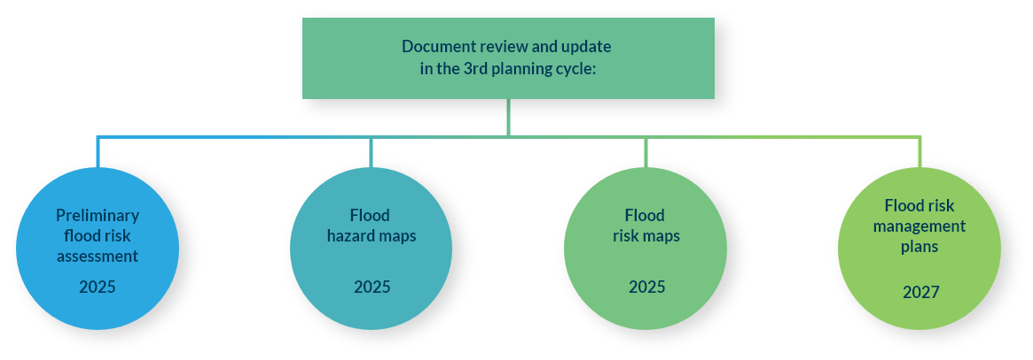
On 21 March 2025 work on the review and update of preliminary flood risk assessment was completed. This was carried out by a consortium consisting of the Institute of Meteorology and Water Management – National Research Institute (Leader) and Arcadis (Partner).
Aim and scope of the PFRA
The purpose of the PFRA is to estimate the flood risk and to identify areas of potential significant flood risk. For these areas, flood hazard maps and flood risk maps are drawn up in the later stages of the implementation of the Floods Directive and measures are established in flood risk management plans.
The main purpose of reviewing and updating the PFRA in the 3rd planning cycle was to complete the data on historical floods and to analyse and assess changes in flood risk since the last update of the PFRA throughout the country, taking into account the division into river basin districts.
Review and update of the preliminary flood risk assessment in the 3rd planning cycle included:
- Identification and description of significant historical floods with an assessment of their adverse impacts on: health and life, economic activity, the environment
and cultural heritage; - Identification and description of floods that may occur in the future (probable floods) together with an assessment of the potential adverse impacts of floods for the same 4 categories as indicated above;
- Carrying out a forecast of long-term developments, including in particular: changes in land use and the impact of climate change on the occurrence of floods;
- Identification of areas of potential significant flood risk.
Once all the analyses had been carried out, a draft report on the review and update of the PFRA was prepared for consultation and agreement under the Water Law Act.
A preliminary seawater flood risk assessment, including internal sea waters, has been included in the draft PFRA prepared by State Water Holding Polish Waters. According to the
Water Law Act, the minister in charge of maritime economy is responsible for preparing a review and update of the preliminary seawater flood risk assessment.
Results
During the 3rd planning cycle, a total of 1,103 historical fluvial floods were identified for the period from 1946 to 2023, of which 304 were considered significant historical floods.
The analyses carried out led to the identification of a total of 1,336 areas of probable fluvial floods and 26 areas of probable floods from damming structures.
The total length of areas of potential significant fluvial floods risk is approximately 29,800 km. In the 3rd planning cycle, around 0.4 thousand km of new river sections were designated as areas of potential significant flood risk.
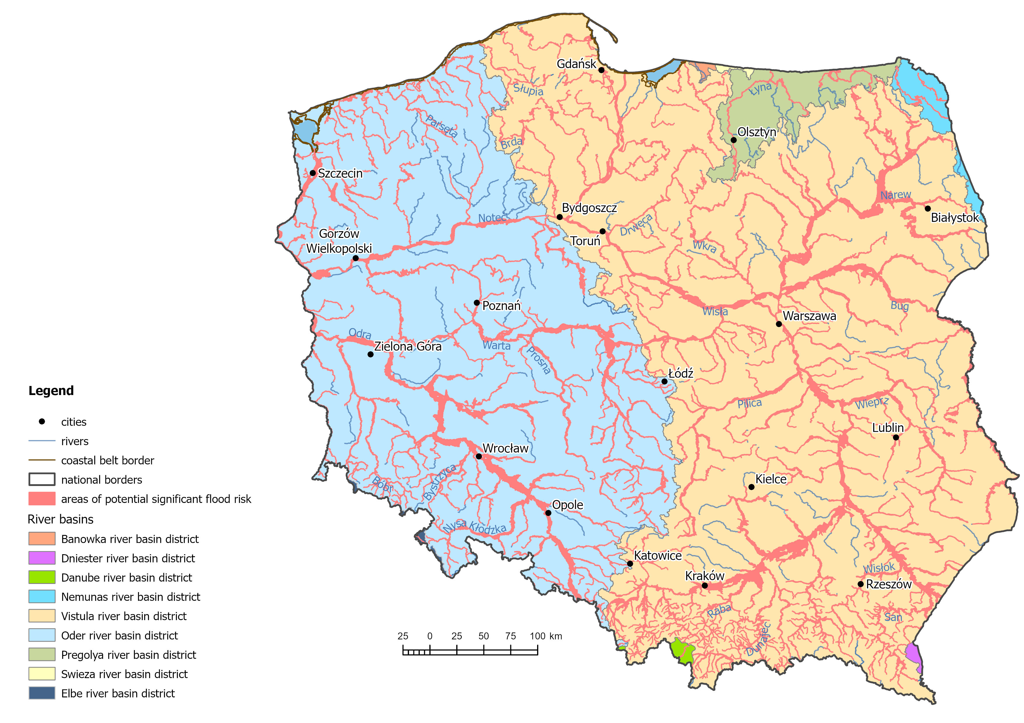
Fig. 1. Map showing the areas of potential significant flood risk for rivers designated in the 3rd planning cycle
For floods from damming structures, 26 areas of potential significant flood risk remain relevant as identified in the 2nd planning cycle.
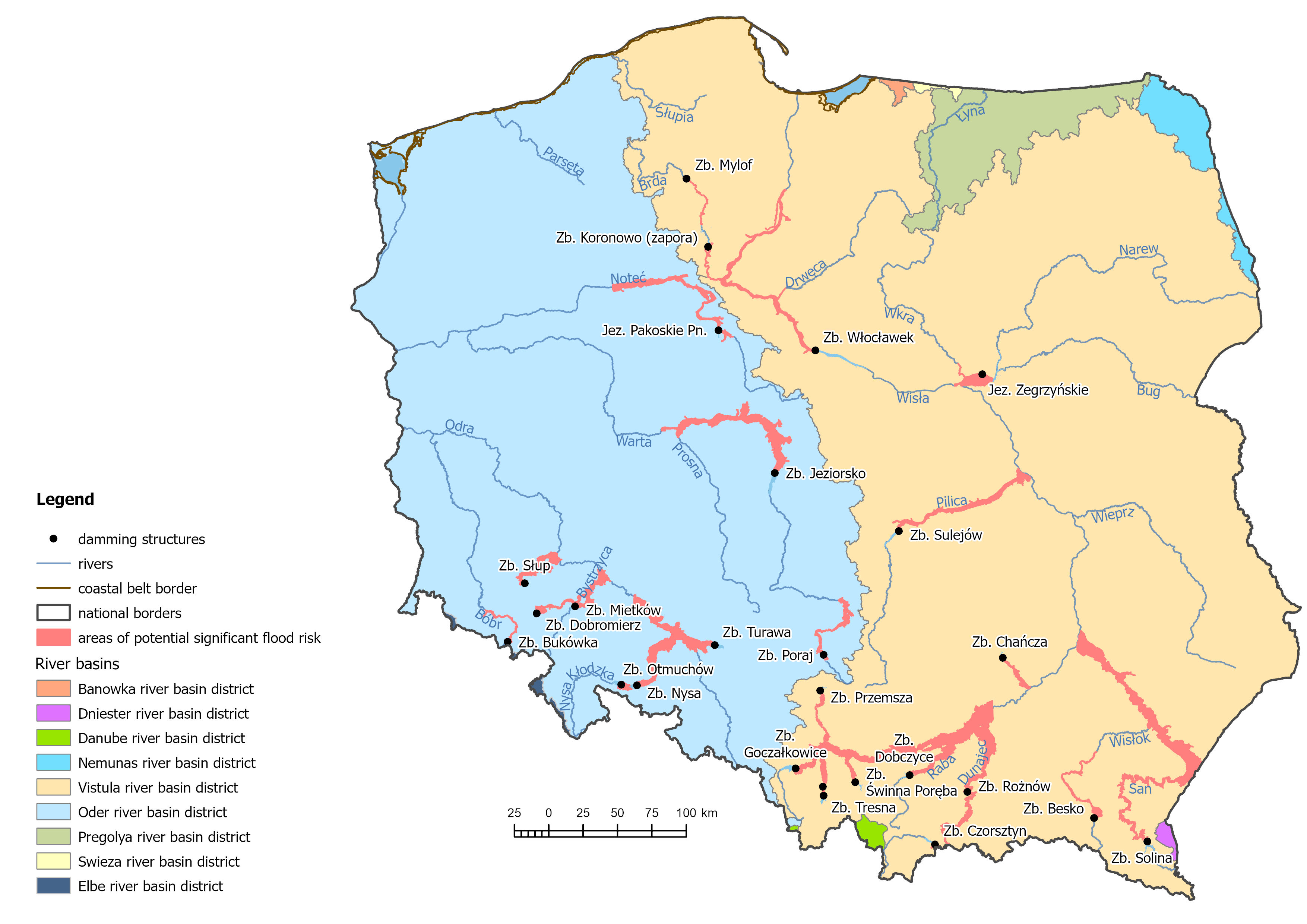
Fig. 2. Map showing the areas of potential significant flood risk from damming structures designated in the 3rd planning cycle
The preparation of a preliminary seawater flood risk assessment, including internal sea waters, and consequently the designation of areas of potential significant seawater flood risk is the responsibility of the minister in charge of the maritime economy. In the 3rd planning cycle a total of 118 areas of potential significant seawater flood risk were identified. All areas of potential significant seawater flood risk, including internal sea waters designated in 1st and 2nd planning cycles remain relevant.
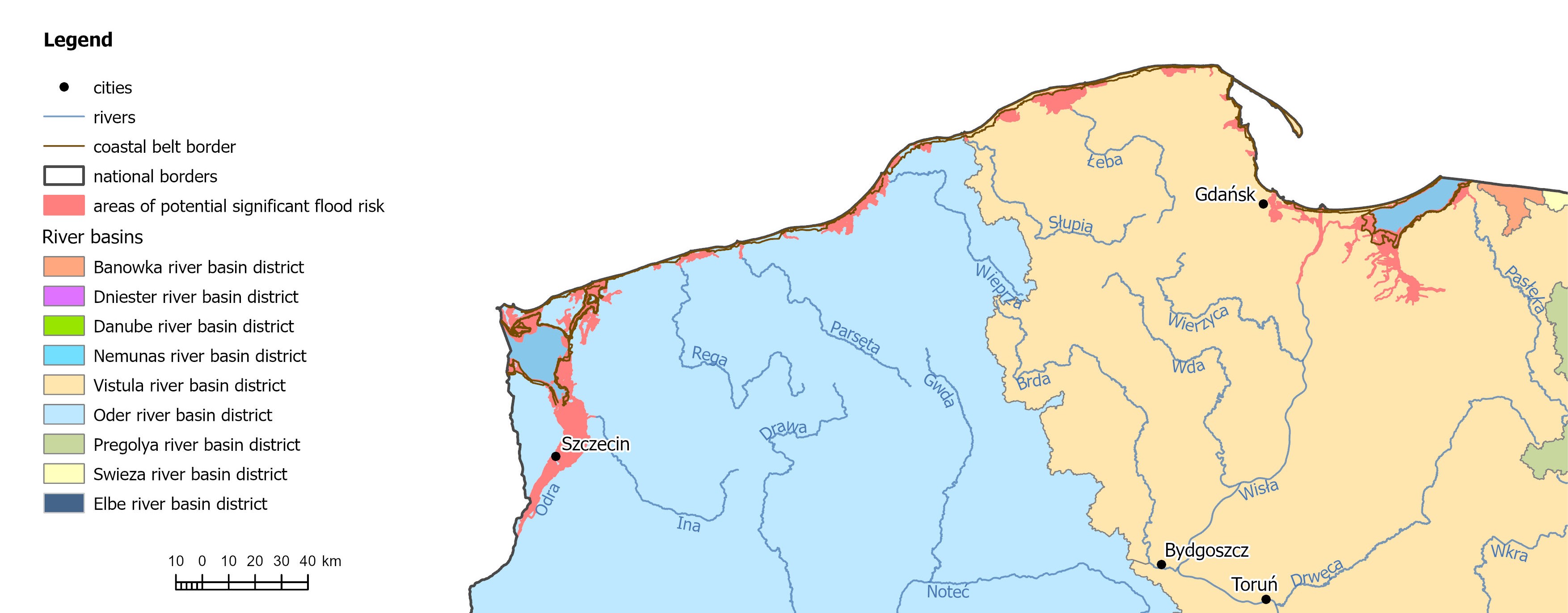
Fig. 3. Map showing the areas of potential significant seawater flood risk designated in the 3rd planning cycle
PFRA review and update report (2025)
A detailed description of the methodology and the scope of the development of the PFRA in the 3rd planning cycle is presented in the "Report on the review and update of the preliminary flood risk assessment in the 3rd planning cycle" and its appendices, available below.
Report on the review and update of the preliminary flood risk assessment
Appendix No. 1 PFRA methodology
Appendix No. 1.1 Structure of the PFRA database
Appendix No. 1.2 Description of the PFRA maps
Appendix No. 2 Methodology for the preliminary seawater flood risk assessment
Appendix No. 3 List of areas of potential significant flood risk
Appendix No. 4 List of significant historical and probable floods
Appendix No. 5 PFRA maps:
Appendix No. 6 Report on the review and update of the preliminary seawater flood risk assessment
Appendix No. 7 Report on the flood in September 2024
Competent authorities and management bodies
The competent authorities and management bodies for matters related to the implementation of Directive 2007/60/EC of the European Parliament and of the Council of 23 October 2007 on the assessment and management of flood risk are described in the report provided below.
Report on competent authorities and management bodies in Poland